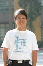
姓 名:楊明德
職 稱:教授
系 所:土木工程學系
電 話:22840440#214
郵 件:mdyang@dragon.nchu.edu.tw
傳 真:22862857
學歷
俄亥俄州立大學土木及環境工程學系博士
俄亥俄州立大學土木及環境工程學系碩士
國立交通大學土木工程學系學士
經歷
現職:國立中興大學土木工程學系教授
國立中興大學土木工程學系副教授
國立中興大學土木工程學系助理教授
朝陽科技大學營建工程系副教授
國立台灣大學土木工程學系博士後研究員
研究領域:土木水利,防災工程,地理資訊系統,衛星遙測
(中文)遙測學(英文)RemoteSensing
(中文)地理資訊系統(英文)Geographiicnformatisoynstem
TELES 發展過程:
有鑒於國家地震工程研究中心近年來在震災損失評估及地區防救災方面有
頗多之成果,為加強國內地震防災觀念,落實地震區域防災計劃規劃訓練,特舉
辦地震損害評估軟體 -- 台灣地震損失評系統 (TELES) 之研討會。
TELES 是 Taiwan Earthquake Loss Estimation System 的首字母縮寫,由國家
地震工程研究中心 (NCREE) 參考原始 HAZ-Taiwan 和 HAZUS 的分析架構與
評估對象,建置評估分析震災損失所需要之資料庫,並利用Microsoft Visual C++
與MapInfo MapBasic 兩種程式來開發的台灣地震損失評估軟體 。TELES 為適合
不同使用者的需求,整合不同的功能於單一應用軟體中,經由分析模式的模組化
設計與圖形化的使用者介面,達到方便更新與使用的目的 。應用上可提供使用
者進行震災早期評估 . 震災境況模擬與震災風險評估等領域的分析功能 。
本研討會之講題內容包括 (1).地震災害潛勢分析 (2).地震災害損失評估 (3).
震災緊急應變之應用 (4).地區災害防救計劃之應用 (5).災損評估系統使用說明與
資料庫。
1 Yang, Ming-Der and Tung-Ching Su, 2007. Automated diagnosis of sewer pipe defects based on machine learning approaches. Expert Systems With Applications, doi:10.1016/j.eswa.2007.08.13. (in press, SCI, IF=0.957)
2 Chen, Yi-Ping and Ming-Der Yang, 2007. Legal Protection and Data Access of Remote Sensing and GIS Database, in 2007IEEE International Geoscience and Remote sensing Symposium.
3 Yang, Ming-Der, Chan-Hsiang Hsu, and Tong-Ching Su, 2007. Optimal cluster numbers of unsupervised classification in Minkowski spaces, in 2007 IEEE International Geoscience and Remote sensing Symposium.
4 Yang, Ming-Der, 2007. A genetic algorithm (GA) based automated classifier for remote sensing imagery. Canadian Journal of Remote Sensing, 33(3), 593-603p (SCI, IF=0.7)
5 Yang, Ming-Der and Tung-Ching Su, 2007. An optimization model of sewerage rehabilitation. Journal of the Chinese Institute of Engineers. 30(4), 651-659p. (SCI, IF=0.125)
6 Yang, M.D,. T.C. Su, C.H. Hsu, K.C. Chang, and A.M. Wu, 2007. Mapping of the 26 December 2004 tsunami disaster by using FORMOSAT-2 images. International Journal of Remote Sensing, Vol 28, Nos 13-14, pp3071-3091. (SCI, IF=1.128, EI)
7 Yang, Ming-Der, and Tung-Ching Su, 2006. Automation model of sewerage rehabilitation planning, Water Science and Technology, Vol 54, No 11-12, pp225-232. (SCI, IF= 0.875, EI)
8 Hsu, Sung-Chi, Ming-Der Yang, Ming-Che Chen, and Ji-Yuan Lin, 2006. Artificial neural network of liquefaction evaluation for soils with high fines content. In Proc. of 2006 International Joint Conference on Neural Networks, 4956-4950. (EI)
9 Kuo, J.T., Wu-Seng Lung, Chou-Ping Yang, Wen-Cheng Liu, Ming-Der Yang, and Tai-Shan Tang, 2006. Eutrophication modeling of reservoirs in Taiwan. Environmental Modelling and Software. 21:829-844 (SCI, IF=1.351).
10 Yang, Ming-Der, Tung-Ching Su, and Yi-Ping Chen, 2005. Priority evaluation of sewerage rehabilitation by AHP. In Optimizing Pipeline Design, Operations, and Maintenance in Today’s Economy (edited by Vipulanandan and Ortega), American Society of Civil Engineers. Virginia. 523-537p. (EI)
11 Yang, Ming-Der, Chan-Hsiang Hsu, and Tong-Ching Su, 2005. DBI and SI as fitness in GA classification for SPOT4 satellite imagery, in 2005 IEEE International Geoscience and Remote sensing Symposium, 3741-3744p. (EI) (NSC93-2625-Z-005-007)
12 Chen, Yi-Ping and Ming-Der Yang, 2005. Legal issues on public access to remote sensing data in Taiwan, in 2005 IEEE International Geoscience and Remote sensing Symposium, 264-267p. (EI)
13 Yang, Ming-Der, Yeh-Fen Yang, Chan-Hsiang Hsu, and Jan-Tai Kuo, 2004. Application of fuzzy theory to satellite data for determining eutrophic status, in 2004 IEEE International Geoscience and Remote sensing Symposium, 4897-4900p. (EI)
14 Yang, M.D., Y.F. Yang, and S.C. Hsu, 2004. Application of remotely sensed data to the assessment of terrain factors affecting Tsao-Ling landside. Canadian Journal of Remote Sensing, 30(4), 593-603p. (SCI, IF=1.284, EI)
15 Yang, Ming-Der and Yeh-Feng Yang, 2004. Genetic algorithm for unsupervised classification of remote sensing imagery. in Image Processing: Algorithms and Systems III, edited by E.R. Dougherty, J.T. Astola, and K.O. Egiazarian, Proceedings of SPIE-IS&T Electronic Imaging, SPIE Vol. 5298, 395-402p. (doi:10.1117/12.538693, EI)
16 Kuo, J.T., Wen-Cheng Liu, Ruey-Tyng Lin, Wu-Sheng Lung, Ming-Der, Yang, Chou-Ping Yang, and Show-Chyuan Chu, 2003. Water Quality Modeling for the Feitsui Reservoir in Northern Taiwan. Journal of the American Water Resources Association, 39(3), .671-688p. (SCI, IF=0.615, EI)
17 Kuo, J. T., and Ming-Der, Yang, 2003. Chapter12: Water Quality modeling in reservoirs. in Environmental Fluid Mechanics (Ed. by Shen et al.), American Society of Civil Engineers. Virginia. 377-420p. (EI)
18 Lin, Ping-Sien, Ji-Yuan Lin, Jui-Chi Hung, and Ming-Der Yang, 2002. Assessing debris-flow hazard in a watershed in Taiwan. Engineering Geology, 66:295-313p. (SCI, IF=0.713, EI)
19 Kuo, J.T., M.D. Yang, W.S. Lung, and C.P. Yang, H.W. Lo, and S.H. Lu, 2001. Water Quality Investigation and Modeling for Feitsui Reservoir, Proceedings of the World Water & Environmental Resources Congress 2001, ASCE. (EI)
20 Yang, Ming-Der, Robert Sykes, and Carolyn Merry, 2000. Estimation of Algal Biological Parameters Using Water Quality Modeling and SPOT Satellite Data. Ecological Modelling 125: 1-13p. (SCI IF=1.652).
21 Kuo, J. T., and M. D., Yang, 2000.Water quality modeling in reservoirs. The Fourteenth Engineering Mechanics Symposium (EM2000) of the American Society of Civil Engineers. (EI)
22 Lin, Ping-Sien, Ji-Yuan Lin, Jui-Chi Hung, and Ming-Der Yang, 2000. Risk assessment of potential debris-flows using GIS. In Debris-Flow Hazards Mitigation: Mechanics, Prediction, and Assessment. Ed. By G. F. Wieczorek and N. D. Naeser. (EI)
23 Yang, Ming-Der and Yeh-Feng Yang, 1999.Eutrophic Status Assessment Using Remote Sensing Data. in Remote Sensing for Earth Science, Ocean, and Sea Ice Applications (Ed. by Cecchi et al.) Vol. 3868, 56-65p. (EI) (NSC-86-2621-E002-017)
24 Yang, Ming-Der, Carolyn Merry, and Robert Sykes, 1999. Integration of water quality modeling, remote sensing, and GIS. Journal of American Water Resources Association, 35(2): 253-263p. (SCI, IF=0.615, EI).
25 Kuo, J.T., M.D., Yang, and C.H., Wang, 1999. Optimization Model for Water Quality Management in Coastal Waters. The Chinese Institute of Environmental Engineering, 9(1): 57-63p.
26 Yang, Ming-Der, and Robert Sykes, 1998. Trophic-dynamics modeling in eutrophic aquatic ecosystems. Ecological Modelling 105: 129-139p (SCI, IF=1.652).
27 楊明德、林佑昌、蔡婷鈺、楊瞱芬,民國96年。衛星影像與模糊理論在水庫水質優養判釋之研究,中國土木水利工程學刊。已接受
28 楊明德、楊曄芬、蘇東青,民國94年。草嶺地區土石流潛勢調查與評估,中華水土保持學報。36(3):301-312。
29 顏聰、林其璋、楊明德,民國93年。七二水災濁水溪災情調查與分析,土木水利雙月刊。31(4):269-33p.
30 楊明德、黃東森、蘇東青,民國92年。污水下水修復本估算,中國土木水利工程學刊。15(4): 93-106p. (NSC-88-2211-E-324-010)
31 楊明德、王瑞德、王慶豐、楊曄芬,民國90年。桃芝颱風對草嶺堰色湖影響之調查分析,中華水土保持學報。34(4): 307-316。
32 陳怡萍、楊明德,民國88年。地理資訊系統之著作權保護,中華地理資訊系統學會通訊。第三卷,第四期,1-7頁。
33 陳怡萍、楊明德,民國88年。電子資料庫之法律問題,國土資訊系統通訊。第二十九期,27-33頁。
34 劉秀媚、游以德、楊明德,民國87年。封閉掩埋場之復育工程,土木技術雜誌,第10期。
35 游以德、楊明德,民國86年。封閉掩埋場之景觀規劃,麻雀變鳳凰。造園季刊,第25期。

沒有留言:
張貼留言